International Court of Justice Defines Maritime Boundary Between Peru and Chile
Introduction
In 2008, Peru filed an application at the International Court of Justice (the Court), claiming that its southern maritime boundary with Chile had not been formally delimited and asking the Court to undertake the task of delimitation using the equidistance method. In response, Chile took the position that the maritime boundary between the two States had been established in 1952 and that it followed a horizontal latitude line starting at the Peru-Chile land boundary and extending to 200 nautical miles (nm).[1] Peru contended that this line, extending from Hito No. 1 (Boundary Marker No. 1 in the Judgment),[2] was merely an informal boundary agreed upon for the purpose of managing innocent incursions from local fishermen close to the shore and related practical use and was never intended to serve as an all-purpose maritime boundary. This parallel, if extended to 200 nm, would deprive Peru of many thousands of square kilometers of maritime space to which it would have had access under a delimitation agreement that utilized the equidistance method. Peru claimed that, since 1982, it repeatedly sought to negotiate a formal maritime boundary with Chile. Chile, arguing that the 1952 line and the agreements that preceded it constituted a formal boundary delimitation, noted instead that the principle of pacta sunt servanda and the importance of stable boundaries negated any considerations in favor of redrawing the boundary. Chile saw no legal obligation to reopen the discussion. The parties concluded their presentations to the Court in December, 2012 and the Court issued its Judgment on January 27, 2014.
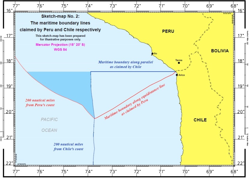
Figure 1: Maritime Boundary Lines Claimed by Peru and Chile Respectively[3]
The Court found that an all-purpose maritime boundary existed between the two states along a horizontal parallel starting at Boundary Marker No. 1 and extending to 80 nm. Beyond the end-point of the parallel boundary, the Court utilized a three-step method to plot an equitable line delimiting the two States' overlapping maritime entitlements extending to 200 nm from each State's relevant coastline.
Background
The origins of this dispute arise from the aftermath of a nineteenth-century territorial war. The "War of the Pacific" resulted in vast territorial transfers from Peru to Chile pursuant to the Treaty of Ancon in 1883 and the Treaty of Lima in 1929. Neither treaty established a maritime boundary. In 1947, both Peru and Chile made unilateral, domestic proclamations claiming an exclusive maritime zone of 200 nm from their respective coastlines. Subsequently, the 1952 Declaration on the Maritime Zone (the Santiago Declaration) and the 1954 Agreement relating to a Special Maritime Frontier Zone (1954 Agreement) resulted in tri-lateral agreements between Peru, Chile and Ecuador. According to Peru, the ostensible purpose of these agreements was for Peru, Chile and Ecuador to establish a common approach for the protection of the maritime zone abutting their coasts, in particular against incursions by foreign commercial fishing vessels. Chile maintains that part of the purpose, and the result, of these agreements was the establishment of a lateral maritime boundary between each State.
At the time of the 1947 proclamations, the Santiago Declaration, and the 1954 Agreement, there was no established State practice for declaring the equivalent of a 200 nm exclusive economic zone (EEZ). There was also no established practice of boundary delimitation. By way of the Truman Proclamation, the United States had claimed the resources of the subsoil and seabed of the continental shelf under the high seas contiguous to the coasts of the United States, but fisheries and water column resources remained subject only to regulatory, not exclusive, jurisdiction.[4] The Truman Proclamation also provided for delimitation of overlapping claims over the continental shelf, though not over any other shared maritime entitlement. Latin American States with significant continental shelves were quick to follow the U.S. proclamation and make similar claims of their own, but States on the Pacific coast had limited continental shelves and could not make identical claims. Within this context, Chile, Peru, and then Ecuador claimed exclusive sovereignty and jurisdiction over marine resources to a distance at least 200 nm from their coastline. This was a novel claim at the time and, according to Peru, was met with some resistance.[5] It was not until the adoption of the 1982 United Nations Convention on the Law of the Sea (UNCLOS) that the concept of the 200 nm EEZ came into common usage.
At the heart of this dispute is access to rich ocean resources in the water column and the seabed. Neither State has a significant continental shelf due to the tectonic convergence zone and deep ocean trench that lies immediately offshore from the Peruvian and Chilean coastlines. However, the proximity of the Humboldt Current (an upwelling of cold, nutrient-rich water) to both Statesâ coastlines means that this area is rich in marine resources.[6] Peru and Chile together account for almost a fifth of the worldâs total annual fisheries catch[7] and the fishing industry is critical to the economies of both countries.[8] Both Peru and Chile also have some offshore oil production.[9]
Geography is of critical importance to this dispute. Chile has a north-to-south coastline while Peru's coastline runs roughly northwest to southeast, is concave in shape, and meets the Chilean border at its point of greatest concavity. A parallel maritime dividing line starting from this point does not therefore deprive Chile of maritime territory to which it might lay claim under current international law of the sea, but it does significantly cut off maritime space to which Peru would have a claim. In practical terms, there is an area where Chile and Peru would have overlapping claims were it not for the dividing line at the parallel. The area in dispute amounts to 67,000 sq km of maritime space.[10]
Judgment
The central questions before the Court were whether a maritime boundary exists between Peru and Chile, and if so, what is the nature and extent of such a boundary. In order to decide the dispute, the Court took into consideration relevant state practices and looked to a series of agreements between the two parties including the 1947 Proclamations, the 1952 Santiago Declaration, and related agreements concluded between 1952 and 1954, including the 1954 Agreement.
Citing to the proposition that an international boundary is not to be easily presumed (Nicaragua v. Honduras),[11] Peru's agents argued that, given the significant loss of maritime space and lack of a clear intent to delimit the maritime zone or a specific agreement as to the location of a dividing line, a boundary delimitation could not be implied from the numerous agreements or state practice of the 1950s and 1960s. Peru asserted that the line was merely an informal boundary for the purpose of managing innocent incursions by fishermen and that it had respected this line out of self-restraint and in the interest of good relations while repeatedly requesting formal negotiations. Asking the Court to delimit the shared maritime space, Peru argued that, under the Treaty of Lima, the appropriate starting point for any maritime boundary between the two States should be Point Concordia (on the coast) and not Boundary Marker No. 1 (merely a marker for the land boundary) because this would result in the loss of land and maritime space for Peru. Chile, on the other hand, argued that the Santiago Declaration did constitute a maritime delimitation, since form and title are irrelevant in international law and the purpose of the various agreements had been to affirm the sovereignty and jurisdiction of each State over its adjacent maritime spaces. Arguing that the Santiago Declaration should be read together with the 1952 and 1954 agreements and their respective travaux preparatoires, Chile asserted that sufficient facts existed to support its claim that a complete delimitation had taken place. Chile further argued that Peruvian state practice subsequent to the agreements demonstrated that Peru understood the parallel as a maritime boundary and not merely as a provisional dividing line. Therefore, Chile argued, the case before the Court was more similar to Romania v. Ukraine,[12] where agreements existed that could form the basis of the boundary and merely needed interpretation, than it was to Nicaragua v. Honduras, where there was no written agreement and Honduras claimed there had been an implicit agreement. Finally, Chile argued that Boundary Marker No. 1 was the appropriate starting point for the maritime boundary because Peru and Chile had come together to identify it as such.
Peru also raised a related issue regarding its jurisdiction over an area within 200 nm of its own coast but beyond Chile's 200 nm limit. According to its agents, Peru had already declared its entitlement to this "outer triangle" (alta mar to Chile) of maritime space, but because it was on the Chilean side of the parallel, Peru's rights had not been formally recognized.[13] Chile argued that this region constituted the high seas and that the fact that it fell within 200 nm of Peru's coastline did not mean it was within Peru's jurisdiction. However, as Chile could not lay claim to this space, Peru maintained that Chile could not prevent Peru, the State with the rightful claim, from doing so.
The Court ruled that the various agreements from 1952-54,[14] within the context of the 1947 proclamations,[15] gave rise to a tacit agreement that an all-purpose maritime boundary existed along the parallel running through Boundary Marker No. 1,[16] and that this tacit agreement was cemented in the 1954 Agreement. According to the Court, the agreements before 1954 had "suggested an evolving understanding between the Parties concerning their maritime boundary" and the 1954 Agreement was "decisive in this respect."[17] Because the earlier agreements had also "expressed claims to the sea-bed and to waters above the sea-bed and their resources," the Court found that the existing "boundary is an all-purpose one."[18]
Turning to the extent of the existing boundary, the Court noted that since the 1954 Agreement had as its specific purpose the management of "innocent and inadvertent violations of the maritime frontier"[19] by fisherman, the boundary "necessarily extends at least to the distance up to which, at the time considered, such activity took place."[20] The Court referred to statistics on the volume and type of fisheries activity by each State in the 1950s, the point at which each State's fishing vessels would cross the parallel if they were sailing directly towards the region where they would make their catch, and general developments in the law of the sea at the time, and found that "evidence at its disposal does not allow it to conclude that the agreed maritime boundary along the parallel extended beyond 80 nm."[21] Subsequent practice by both States, including enforcement activities, the building of lighthouses, and national legislation, did not lead the Court to alter its finding on the existence, nature or extent of the boundary. The remaining maritime space of overlapping entitlements therefore required formal delimitation.
In order to delimit the maritime boundary beyond 80 nm along the parallel, the Court used a three-step method designed to reach an equitable solution.[22] Using the equidistance method identified in UNCLOS Articles 74(1) and 83(1) and subsequently recognized as customary international law, the Court plotted a provisional line starting at Point A (the end of the 80 nm boundary line) and equidistant from base points located on each State's relevant coast. This line extends in a south-west direction out to 200 nm as measured from Chile's coastline (Point B).[23] The Court noted that beyond Point B, the parties no longer have overlapping claims on the basis of equidistance. Therefore, the provisional line ends where the Parties' entitlements intersect (Point C) and Chile's entitlements continue further along a north-south line. Peru also retains entitlements to areas beyond the Parties' overlapping entitlements, including the area identified by its agents as the "outer triangle." The Court then examined the record for relevant circumstances that would cause it to adjust the provisional equidistance line and found that none existed. Finally, noting that the proportionality analysis required not an arithmetic calculation but a general examination for equity, the Court ruled that there was no apparent disproportionality in the resulting provisional line.
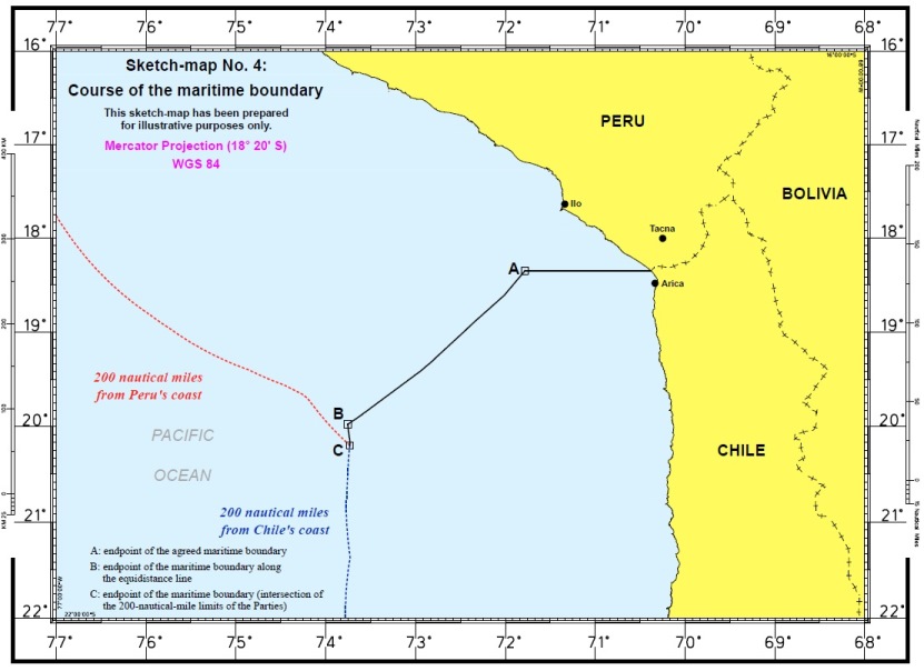
Figure 2: Course of the Maritime Boundary[24]
Political and Legal Consequences
In the weeks leading up to the Court's decision, both parties publicly stated that they would comply with the Court's judgment; it remains to be seen whether this will be the case. The political and legal consequences of this decision are not difficult to foresee. Even before the Court issued its judgment, Bolivia had filed an application with the Court asking that Chile be required to grant it a corridor to access the sea.[25] Given the political fallout from the decision in Nicaragua v. Colombia,[26] where Colombia withdrew from the Pact of Bogota that gives the Court compulsory jurisdiction over disputes among its signatories, it will be interesting to see whether this subsequent decision will have a similar impact on the membership of the Pact, or if there will be similar delays in the implementation of the Court's decision.
About the Author: Uzma S. Burney (J.D., University of Michigan Law School) is a member of ASIL. She currently practices in Boston, Massachusetts. All views expressed in this Insight are her own.
[1] Maritime Dispute (Peru v. Chile), Judgment, ¶ 22 (Jan. 27, 2014) [hereinafter Judgment], http://www.icj-cij.org/docket/files/137/17930.pdf.
[2] Hito No. 1 (Boundary Marker No. 1 in the Judgment) is located at astronomical latitude 18° 21' 03" S. Id. ¶ 14.
[3] Id. at 16.
[4] Proclamation No. 2667, 10 Fed. Reg. 12303 (Sep. 28, 1945).
[5] Maritime Dispute (Peru v. Chile), Verbatim Record, ¶¶ 16 (Dec. 3, 2012, 3 p.m.) [hereinafter Verbatim Record], http://www.icj-cij.org/docket/files/137/17204.pdf.
[6] S. Heileman, R. Guevara, F. Chavez, A. Bertrand, & H. Soldi, XVII-56 Humboldt Current: LME #13, Large Marine Ecosystems of the World, http://www.lme.noaa.gov/index.php?option=com_content&view=article&id=59:lme13&catid=41:briefs&Itemid=72; Permanent Commission for the South Pacific, Humboldt Current: GIWA Regional Assessment 64 13--21 (2006), http://www.unep.org/dewa/giwa/areas/reports/r64/regional_definition_giwa_r64.pdf.
[7] Heileman et al., supra note 5, at 4.
[8] From 1992 to 2001, fishing exports amounted to 16.8% of Peru's total exports and 0.57% of the GDP. Similarly, between 1996 and 2001, fishing and aquaculture amounted to 5.6% of Chile's total exports and 1.4% of its GDP. Permanent Commission for the South Pacific, supra note 5, at 20.
[9] Id. at 21.
[10] Verbatim Record, supra note 4, ¶ 11.
[11] Territorial and Maritime Dispute between Nicaragua and Honduras in the Caribbean Sea (Nicar. v. Hond.), Judgment, 2007 I.C.J. 659 (Oct. 8) [hereinafter Caribbean Sea Judgment], http://www.icj-cij.org/docket/files/120/14075.pdf.
[12] Maritime Delimitation in the Black Sea (Rom. v. Ukr.), Judgment, 2009 I.C.J. 61 (Feb. 3) [hereinafter Black Sea Judgment], http://www.icj-cij.org/docket/files/132/14987.pdf.
[13] Maritime Dispute (Peru v. Chile), Reply of the Government of Peru, ¶ 2, at 331 (November 9, 2010), http://www.icj-cij.org/docket/files/137/17190.pdf. The Court ruled that as the parallel boundary line was found to end at 80 nm from the coast, the "Chilean argument does not exist" and Court's own delimitation of the overlapping entitlements utilizing the equidistance method rendered Peru's claim moot. Judgment, supra note 1, ¶ 189.
[14] The Court found that Santiago Declaration had the status of an international treaty, but lacked "reference to the delimitation of maritime boundaries" and did not include information "expected in an agreement determining maritime boundaries, namely, specific co-ordinates or cartographic material." Judgment, supra note 1, ¶ 58. However, the stated object and purpose of the Declaration, and the relevant travaux preparatoires, suggested the existence of "some sort of shared understanding among the State parties of a more general nature concerning their maritime boundaries"at this time. Id. ¶ 69.
[15] Regarding the Proclamations, the Court found that they did not "reflect a shared understanding" concerning a lateral boundary between the two States, though they identified the need for such a delimitation. Id. ¶ 43.
[16] The Court found that both Partiesâ statements at the time they undertook the building of lighthouses in 1968-69, were "compelling evidence that the maritime boundary follows the parallel that passes through Boundary Marker No. 1." Id. ¶ 174.
[17] Id. ¶ 91.
[18] Id. ¶ 102.
[19] Id. ¶ 90.
[20] Id. ¶ 103.
[21] Id. ¶ 117.
[22] Here citing to its own practice, most recently in the Black Sea Judgment and Caribbean Sea Judgment.
[23] The Court found that Chile's first basepoint was located near the starting point of the maritime boundary at the parallel; Peru's first basepoint was located "at a point where the arc of a circle with an 80 nm radium from Point A intersects with the Peruvian coast." Judgment, supra note 1, ¶ 185. Point A is where the existing maritime boundary ends. Id. ¶ 183.
[24] Id. at 66.
[25] Bolivia Takes Chile Sea Dispute to International Court, BBC News (Apr. 24, 2013), http://www.bbc.co.uk/news/world-latin-america-22277407.
[26] Territorial and Maritime Dispute (Nicar. v. Colom.), Judgment, 2012 I.C.J. 624 (Nov. 19), http://www.icj-cij.org/docket/files/124/17164.pdf.