The World Court Fixes the Somalia-Kenya Maritime Boundary: Technical Considerations and Legal Consequences
Introduction
On October 12, 2021, the International Court of Justice (ICJ) delivered its final ruling in the Maritime Delimitation in the Indian Ocean (Somalia v. Kenya) case.[1] This Insight provides a law-and-science summary of the case and explains how the apparent technical flaws in the ICJ's ruling have spatial, practical, and legal consequences as well as potential geopolitical repercussions.
Background
The maritime boundary dispute between Kenya and Somalia, adjacent states bordering the Indian Ocean, essentially arose from their fundamentally differing approaches to maritime delimitation. Somalia instituted proceedings against Kenya through an Application to the ICJ in August 2014, requesting that the Court establish a single maritime boundary delimiting the territorial sea, exclusive economic zone (EEZ) and continental shelf, including seawards of 200 nautical miles (M) from the coast. Kenya raised preliminary objections to the Court's jurisdiction and the admissibility of Somalia's Application in 2015,[2] but these were rejected by the ICJ in 2017.[3] After delays, including the COVID-19 pandemic, hearings on the merits of the case were finally held in March 2021. However, three days prior to the start of these hearings Kenya informed the Court that it would not be participating in the hearings due to the Court's refusal to postpone the hearings further.
The Parties' Positions
Somalia premised its request for a maritime boundary delimitation on its claim that there was no pre-existing boundary with Kenya and argued that an equidistance line (i.e., a line every point of which is at an equal distance from the nearest points on the baselines of each state) was the appropriate method to delimit the boundary between the two states. In contrast, Kenya asserted that a boundary already existed between the parties consistent with Kenya's claim line along the 1° 39' 443.2 S parallel of latitude.
Kenya maintained that Somalia had acquiesced to its unilateral parallel of latitude claim primarily on the basis that Somalia had not responded to Kenya's 1979 claim until 2014.[4] In response, Somalia argued that it was "unreasonable and unrealistic" for Kenya to expect Somalia to respond diplomatically to its claims when Somalia was embroiled in a civil war that deprived it of a functioning government between 1979-2014.
ICJ Decision
Noting the "high threshold" for proof regarding the establishment of a maritime boundary through acquiescence[5] and also bearing in mind Somalia's arguments concerning its civil war and resulting lack of a government in the period 1991-2005,[6] the Court rejected Kenya's contention that a maritime boundary consistent with the parallel of latitude already existed between the parties.[7] Hence, it was for the ICJ to fix the boundary.
Locating the Land Terminus Point on the Coast
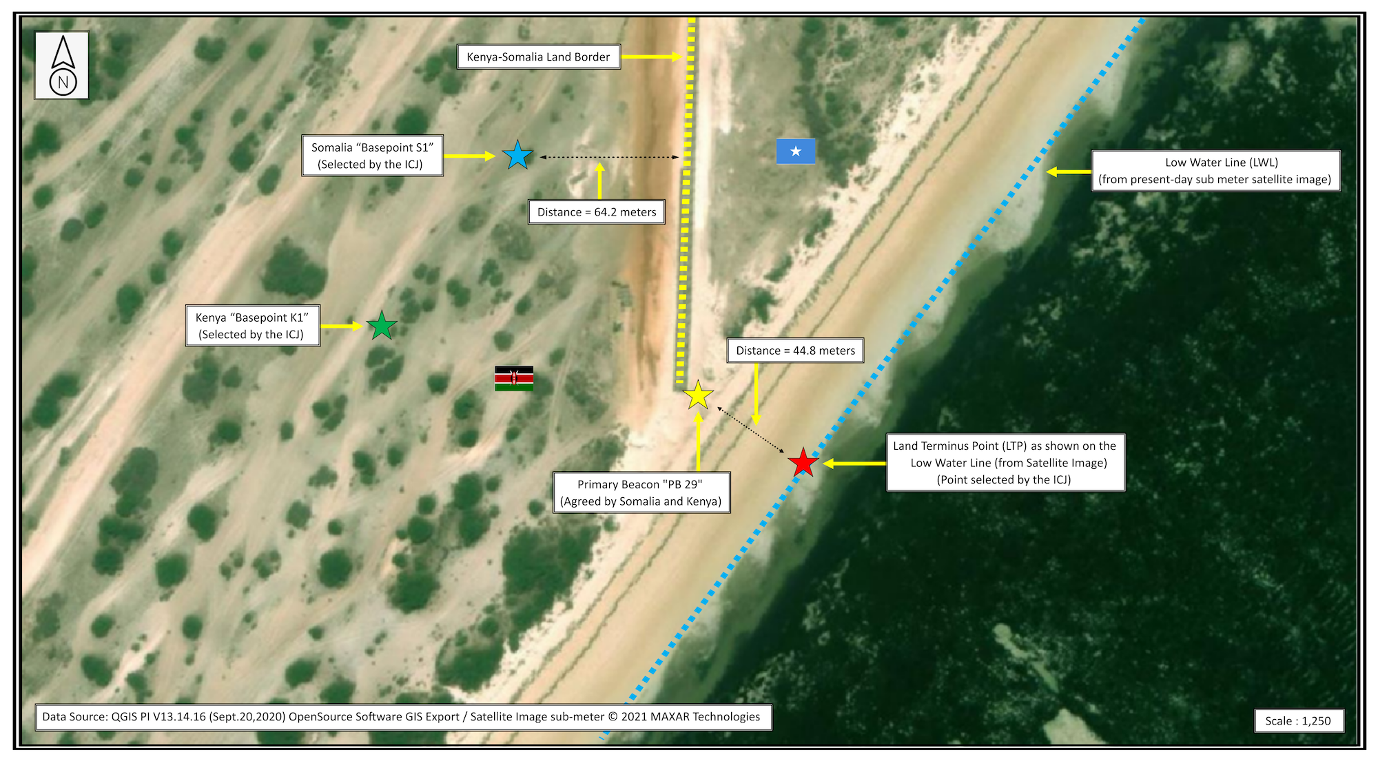
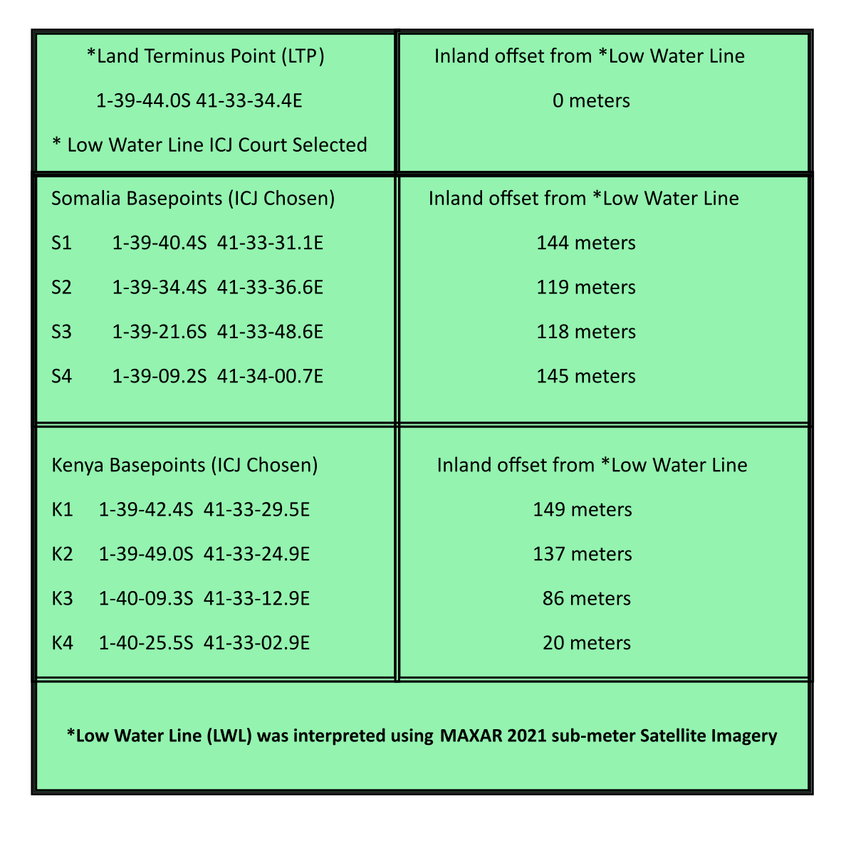
Prior to the independence of the parties, the former colonial powers, Italy and Great Britain, had settled the land border issues through a 1927 agreement and exchange of notes in 1933.[8] Although the parties indicated different coordinates for the location of the final permanent border beacon closest to the coast, Primary Beacon No. 29 (PB 29), these differences were slight (approx. 9.8 meters), and Somalia indicated that it was willing to accept the coordinates proposed by Kenya.[9]
The ICJ then endeavored to connect PB 29 to a point on the coastal low-water line as the land terminus point (LTP) that would be used as the starting-point for the maritime boundary. It did so by defining a straight line perpendicular to the general direction of the coast in the vicinity of the land border terminus as it appeared on a British Admiralty Chart.[10] The point located by the Court is 44.8 meters southeast of PB 29 and, importantly, is consistent with the location of the low-water line that can be discerned from high-resolution satellite imagery (See Figure 1).[11] However, the Court's use of the relatively small scale (1:350,000) nautical chart which incorporated dated surveys is problematic, not least because the coastline in the vicinity of the land terminus point as depicted on the chart is predominantly well inland of the location of the coast indicated on satellite imagery, resulting in later complications when the maritime boundary was delimited (see below).[12]
The Court's Approach to Maritime Delimitation
Both Kenya and Somalia are parties to the United Nations Convention on the Law of the Sea (UNCLOS).[13] Accordingly, for the territorial sea the ICJ opted to define a median line, in keeping with Article 15 of the UNCLOS, and it adopted the now well-established three-stage approach as the basis for delimitation of the EEZ and the continental shelf.[14]
Delimitation of the Territorial Sea
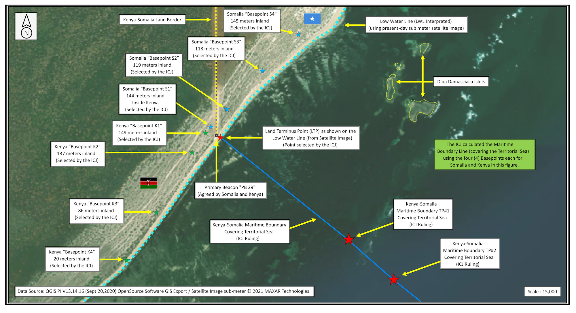
In drawing a median line for the delimitation of the territorial sea, the ICJ selected base points along the mainland coasts of the parties, ignoring small offshore features (See Figure 2).[15] The Court selected four base points for each part, designated S1-S4 and K1-K4.
Problematically, the Court appears to have relied on the above-mentioned British Admiralty chart, which depicts the coastline substantially landward of its present location. Consequently, the base points selected by the Court are substantially inland from the actual location of the coast (See Figure 2 and Table 1). Our analysis shows that the court-selected basepoints are on average over 100 meters inland, and that Somalia's base point 1 (S1) is located 64.2 meters on the Kenyan side of the land border. This is especially perplexing given the Court's earlier efforts to locate the starting point of the maritime boundary on the low-water line, to the southeast of PB 29 (See Figures 1 and 2).
Utilizing these eight base points only, ignoring small island features such as the Diua Damasciaca islets, the ICJ, on the basis of equidistance, designated six points to define the territorial sea boundary together with a further point,[16] designated "Point A." Despite the clear intent of the Court to only delimit the territorial sea to the 12 M limit,[17] the coordinates provided by the Court for the terminus of the territorial sea boundary at Point A are located almost 13 M (approx. 12.91 M) from the terminus of the land border on the coast (See Figure 3).[18]
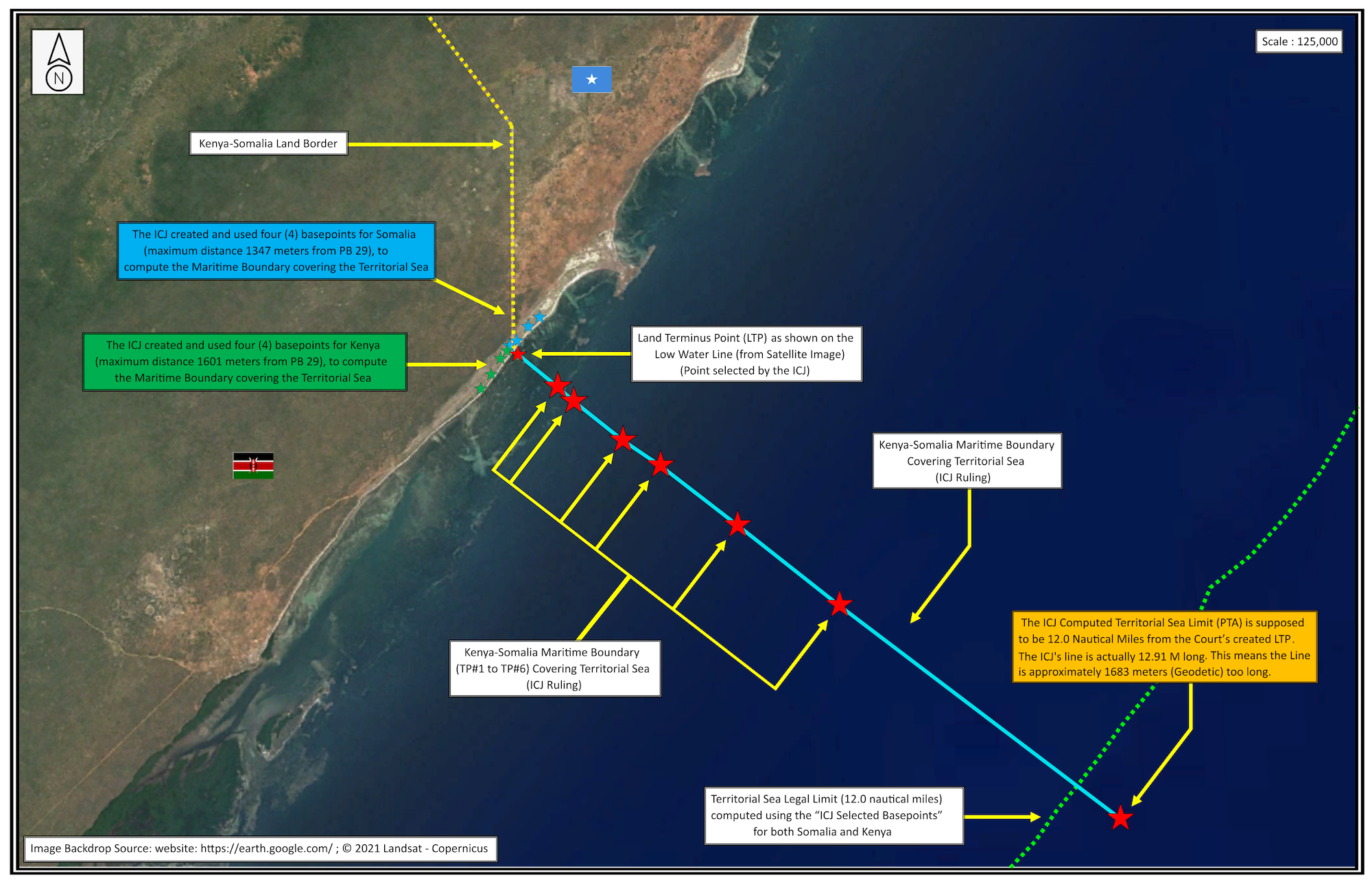
EEZ and Continental Shelf Delimitation
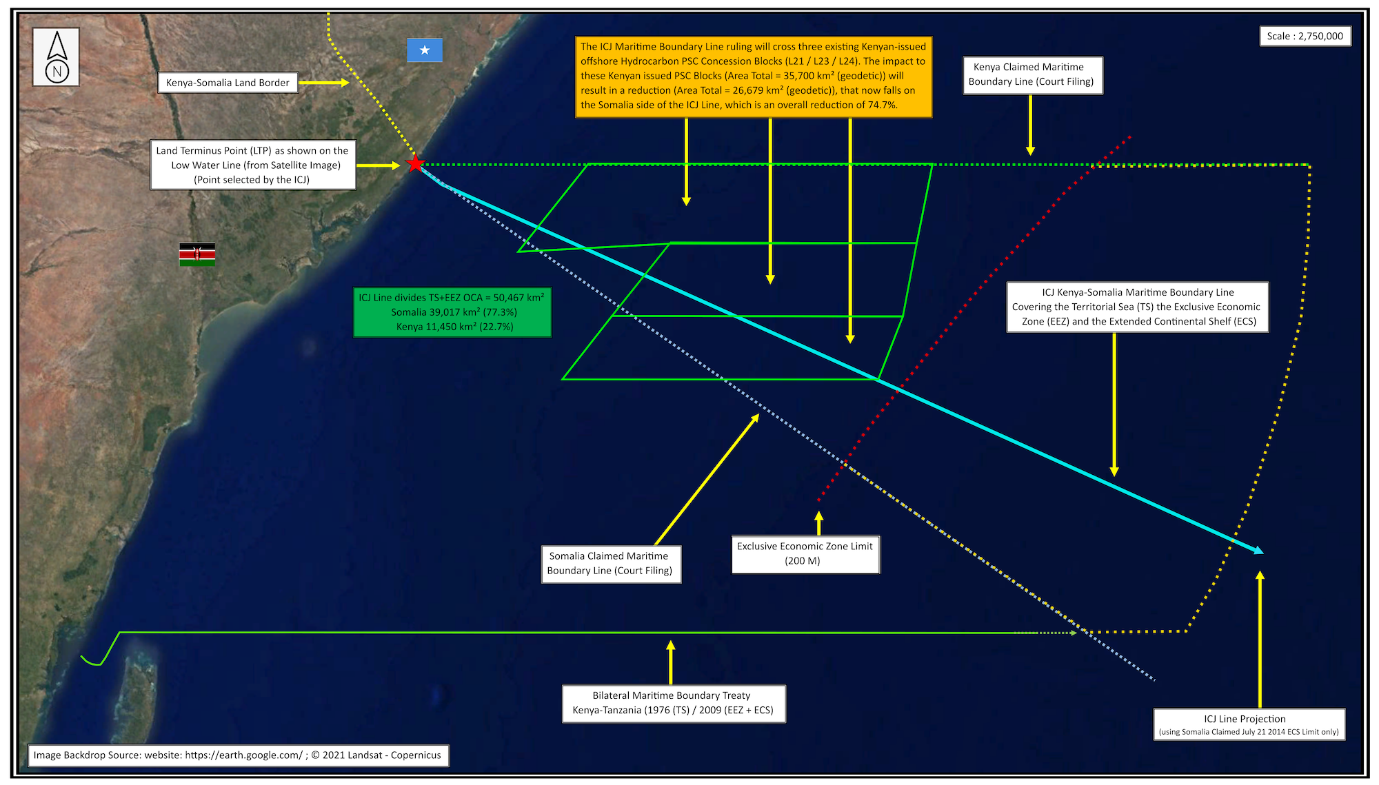
The ICJ then turned to the first stage of the three-stage process and constructed a provisional equidistance line. At the second stage, involving consideration of relevant circumstances that might lead to an adjustment of the provisional line, the Court observed that when the coasts of Kenya and Somalia are examined in isolation, "any concavity is not conspicuous."[19] However, the Court viewed the concavity of the coastline in the broader East African regional context, including the coast of Tanzania,[20] and on this basis found that the coastal projection of Kenya was narrowed, substantially reducing its maritime entitlements within 200 M of the coast.[21] Accordingly, the ICJ adjusted the EEZ delimitation line northwards such that from Point A it follows a compass bearing of 114° (See Figure 4). The vote on this boundary segment was 10-4.
However, as a direct consequence of the apparent error in the location of Point A, there are inevitable "knock on" consequences for the EEZ and continental shelf boundaries (See Figures 4 and 5).
Delimitation of the Continental Shelf Beyond 200 M from the Coast
Concerning delimitation of the continental shelf seawards of 200 M EEZ limits, the ICJ decided, by nine votes to five, that a continuation of the adjusted line was appropriate, to the outer limits of the parties' continental shelves.[22] Again, as a consequence of the discrepancy in the location of Point A, portions of the outer continental shelf were allocated to Somalia rather than Kenya. In total, approximately 324.1 km2 or 94.4 square nautical miles, of the combined EEZ and continental shelf areas beyond 200 M EEZ limits lies within the Somali, rather than Kenyan, side of the boundary line (See Figure 5).
As the outer continental shelf limits submitted by Somalia to the Commission on the Limits of the Continental Shelf (CLCS) are, in places, considerably seawards of those submitted by Kenya for areas of continental shelf located on the Kenyan side of the adjudicated boundary line, some readjustment to Kenya's outer continental shelf limits may eventuate. Further, the ICJ acknowledged that, in light of the unpredictable outcome of the CLCS procedure, its ruling has the potential to give rise to a "grey area" located beyond 200 M from Kenya but within 200 M of Somalia but on the Kenyan side of the delimitation line, meaning that in this area Kenya would have jurisdiction over the seabed and Somalia would have jurisdiction over the water column (See Figure 5).[23]
Conclusions
The ICJ's ruling in the Somalia-Kenya case is consistent with earlier international jurisprudence in terms of locating the starting base point for maritime delimitation on the low-water line from a final land border marker. The ruling also reflects established practice in terms of the construction of the median line for the territorial sea delimitation, while ignoring small insular features that might disproportionately distort the course of that line, and in applying the three-stage process to the delimitation of the EEZ and continental shelf. This resulted in a boundary line that divided the overlapping claims area and thus yielded an outcome that is somewhat more palatable to Kenya. Indeed, while the split of the overlapping claims area was roughly 77:23 in Somalia's favor, Kenya still secured around 64 percent of its claimed maritime jurisdiction prior to the case. The Court's decision to continue the delimitation line for the continental shelf seawards of the 200 M limit in the same direction as for the area within 200 M limits was also consistent with past decisions.
It can be observed that the ruling has significant practical impacts in terms of access to marine resources, particularly with respect to fisheries and potential seabed hydrocarbons. For example, Kenya has issued three offshore hydrocarbon concessions to a major oil and gas company of which approximately 75 percent fall on the Somali side of the ICJ's boundary line (See Figure 5).
The technical flaws apparent in the ICJ's Judgment are troubling and may undermine its authority. The Court's reliance on a relatively small-scale nautical chart based on dated surveys that does not reflect the physical reality of the coast as readily detectable using high-resolution satellite imagery is questionable. Further, the ICJ's delimitation of a territorial sea boundary almost 13 M long is in direct contravention of the provisions of the UNCLOS. This error is then magnified further offshore such that overall around 350 km2 of maritime jurisdiction is, as it were, "on the wrong side of the line." At the same time, the Court's decision on the boundary is binding for Somalia and Kenya and is final and without appeal. It is therefore uncertain whether Kenya would be successful if it were to raise the technical errors apparent in the ruling and seek their correction. Even were this to occur it presently seems unlikely, based on the pronouncements of prominent Kenyan politicians, that Kenya will comply with the ruling. However, these apparent errors only help to undermine the Court's decision.
Indeed, the deficiencies in the ICJ's ruling raise serious concerns over the technical input into the Court's deliberations. While it is apparent from the technical content of the ruling that the Court has some access to technical input, it is unclear precisely who provides this support.[24] These errors lead to spatial, legal, and practical consequences. This suggests that enhanced technical input into the Court's decision-making process is warranted with greater transparency as to the source of this technical input.[25]
About the Authors:
Clive Schofield, LL.M. (UBC), Ph.D. (Durham), is Head of Research at the WMU-Sasakawa Global Ocean Institute, World Maritime University in Malmö, Sweden, and Professor with the Australian Centre for Ocean Resources and Security (ANCORS), University of Wollongong (UOW), Australia (chs@wmu.se). His research interests relate to international maritime boundary delimitation and geo-technical issues related to the law of the sea. A joint Australian and UK national, he is an Observer on the Advisory Board on the Law of the Sea (ABLOS) and is a member of the International Law Association's Committee on International Law and Sea Level Rise. He has also been involved in the peaceful settlement of boundary and territory disputes through negotiated and adjudicated means.
Pieter Bekker, LL.M. (Harvard), Ph.D. (Leiden), an ASIL member, holds the Chair in International Law at the University of Dundee's Centre for Energy, Petroleum and Mineral Law and Policy (CEPMLP), where he is Founding Director of the Dundee Ocean and Lake Frontiers Initiative and Neutrals (DOLFIN) (p.bekker@dundee.ac.uk). A Dutch national, he is also a Partner at CMS Cameron McKenna Nabarro Olswang LLP. A former staff lawyer in the ICJ Registry and member of the New York Bar, he has appeared as counsel in numerous cases before international courts and tribunals, including the ICJ and ITLOS.
Robert van de Poll, B.Sc. (Earth Sciences), M.Sc.Eng. (Geodesy & Geomatics), is Global Director Law of the Sea for Fugro, one of the world's largest surveying and engineering companies headquartered in The Netherlands (rvandepoll@fugro.com). He is the creator of CARIS LOTS, the leading Law of the Sea and maritime boundary software used by the United Nations and by international courts and tribunals. A Canadian national, he also serves as Geology Director of DOLFIN and as a CEPMLP Honorary Lecturer (University of Dundee, UK), as a Visiting Fellow at the IMO International Maritime Law Institute, Malta University, Malta, and as an Honorary Fellow at ANCORS, UOW, Australia.
The views expressed herein are solely those of the authors, who had no involvement in the ICJ case. Errors are the authors' responsibility.
[1] Maritime Delimitation in the Indian Ocean (Som. v. Kenya), Judgment (Oct. 12, 2021), https://www.icj-cij.org/en/case/161 [hereinafter Somalia-Kenya Case].
[2] Counter-Memorial of Kenya, https://www.icj-cij.org/en/case/161; Somalia-Kenya Case, ¶ 7.
[3] Somalia-Kenya Case, Preliminary Objections (Feb. 2, 2017), https://www.icj-cij.org/en/case/161.
[4] Proclamation of the President of the Republic of Kenya (Feb. 28, 1979), https://www.un.org/Depts/los/LEGISLATIONANDTREATIES/PDFFILES/KEN_1979_Proclamation.pdf. See, Somalia-Kenya Case, ¶ 38.
[5] Somalia-Kenya Case, ¶ 52.
[6] Id. ¶ 79.
[7] Id. ¶ 89.
[8] Termed the "1927/1933 treaty arrangement" by the ICJ. Id. ¶ 32.
[9] Id. ¶ 96.
[10] Specifically, British Admiralty Chart 3362. This approach was consistent with the practice in other international cases such as that taken in the Ghana-Côte d'Ivoire case. See, Case Concerning Delimitation of the Maritime Boundary Between Ghana and Côte d'Ivoire in the Atlantic Ocean (Ghana/Côte d'Ivoire), Case No. 23, Judgment of Sept. 23, 2017, https://www.itlos.org/en/main/cases/list-of-cases/case-no-23/ [hereinafter Ghana-Côte d'Ivoire case].
[11] QGIS PI 13.14.16 (64-bit) Open source Software. (Version Sept. 20, 2020). Border / Marine Regional analysis Dar es Salam Kenya & Somalia. 1°55'50.32"S, 42° 5'34.05"E, Scale 1:1250. © 2021 MAXAR Technologies (Imagery Accessed November 15, 2021).
[12] The United Nations Group of Experts report on baselines cautions against the use of charts that are too old and recommends the use of charts of 1:50,000-200,000 scale for the depiction of baselines. See, United Nations, Baselines: An Examination of the Relevant Provisions of the United Nations Convention on the Law of the Sea (DOALOS, New York, 1989), at pp. 1-2.
[13] See, United Nations Convention on the Law of the Sea (Montego Bay, Dec. 10, 1982, in force Nov. 16 1994) 1833 U.N.T.S. 396 [hereinafter UNCLOS]. Both Kenya and Somalia signed the Convention on December 10, 1982, ratifying it on March 2, 1989 and July 24, 1989, respectively. See, Somalia-Kenya Case, ¶¶ 33 and 92.
[14] Somalia-Kenya Case, ¶¶ 122-125, 131.
[15] Id. ¶ 113.
[16] Id. ¶ 117.
[17] Id. and illustrated by Sketch Map No. 5 on p. 42 of the Judgment.
[18] See, UNCLOS, arts. 3-4.
[19] Somalia-Kenya Case, ¶164. The ICJ recognized that the construction of an equidistance line can produce a cut-off effect where the coastline is characterized by a concavity. Id. ¶ 162.
[20] Id. ¶¶ 165-167.
[21] Id. ¶169.
[22] Id. ¶ 196.
[23] Id. ¶ 197.
[24] The Court's Judgment lists the Judges and Counsel involved in the case, but is silent concerning the identity of any technical support for the Court.
[25] Here it is notable that earlier cases have emphasized the importance of transparency and predictability in the maritime boundary delimitation process. See, e.g., Ghana-Côte d'Ivoire Case, ¶¶ 281, 289.